The only plastic we need for travel.
Google Maps’ Latest Feature Lets You Locate COVID-19 Hotspots

In a country now notorious as a COVID-19 hotspot in Southeast Asia, moving from one location to another can be unsettling. Even more so compared to the earlier days of the community quarantines in the Philippines. While most of us have been relying on news and government portals to know the safest places to go this pandemic, there’s also now a new Google Maps COVID-19 feature that makes the same information available.
With the new tool, Google Maps users, including those in the Philippines, can find out the COVID-19 case trends in a particular place. This way, they’ll know which places they can go and those that they should avoid to reduce the chances of contracting the virus.
Also read: COVID-19 Philippines Travel Advisory for Filipinos & Foreign Visitors
How the new Google Maps COVID-19 feature works
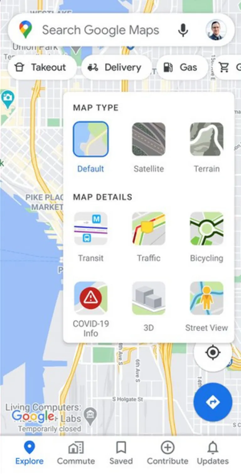
If you’re going out, you can try the new feature by simply tapping the layers button located on the upper right hand of your Google Maps screen. There, you’ll find the “COVID-19 info” tool which you must click to access the average number of COVID-19 cases per 100,000 people in a shown area. This information is based on data collected in seven days.

In addition, you’ll find a label that indicates whether the COVID-19 cases in that area are increasing or decreasing. For example, areas shown in grey means that they only have one new case within the seven-day period. Meanwhile, if you see that an area is shown in a dark red colour, you should try to avoid because this means it has recorded at least 40 cases in the same period.
According to Google Maps Product Manager Sujoy Banerjee, the data reflected in the new Google Maps COVID-19 feature originate from institutions like the World Health Organization. They also include government health ministries, local health agencies, and hospitals. “Many of these sources already power COVID case information in Search, and we’re now expanding this data to Google Maps.”
Also read: 8 Mobile Banking Apps Every Pinoy Should Have
Google Maps in the time of the pandemic
Before this COVID-19 layer, Google’s web mapping service has also been providing users the world over with other useful information during the pandemic. Among them is showing certified COVID-19 testing centres in the Philippines. You can do this by typing “covid testing” on either Google Search or Google Maps.

Another handy feature on Google Maps to help Filipino medical frontliners safely move around during their duties is the hospital shuttle route. This was launched in partnership with the Department of Transportation and the Department of Health. Through it, health workers can see the available shuttle routes and estimated travel time. Just key in your destination, go to “Directions”, then the public transit tab.
While the latest Google Maps COVID-19 feature hasn’t rolled out in the Philippines yet, when it does, more Filipinos can use it to fulfil essential activities while staying safe from COVID-19. Also, be sure to update your Google Maps application regularly to take advantage of its other COVID-19 features.
Published at
About Author
Joser Ferreras
Subscribe our Newsletter
Get our weekly tips and travel news!
Recommended Articles
14 Best Credit Cards for Travel in the Philippines 11.11 Seat Sales to Fly to Your Revenge Travel Destination The savings are beyond comparison!
The 2021 Global Korea Scholarship Is Accepting Applications This March Don’t miss this chance!
2021 Planners: Our Top Picks & Where to Buy Them 2021, come faster!
This 2022 Japan Postgraduate Scholarship Grant Is Now Open for Pinoys You can finally study in Japan for free!
Latest Articles
Mother’s Wonderland: Quezon Province’s Fantasy Theme Park Explore a magical theme park in Tayabas filled with nature, art, and fantasy
Kayangan Lake in Coron, Palawan: Everything You Need to Know Dive into the crystal-clear magic of Kayangan Lake, the crown jewel of Coron, Palawan!
Dingalan Travel Guide: Nature Spots to Discover Now Underrated coastal gem in Aurora
What to Eat in Bicol: Iconic Dishes and Treats, and Unique Pasalubong You’ll Love Spice up your foodie adventure with iconic Bicol dishes and must-try pasalubong!
Top Travel Trends in the Philippines for 2025 New spots, tips, and trends

